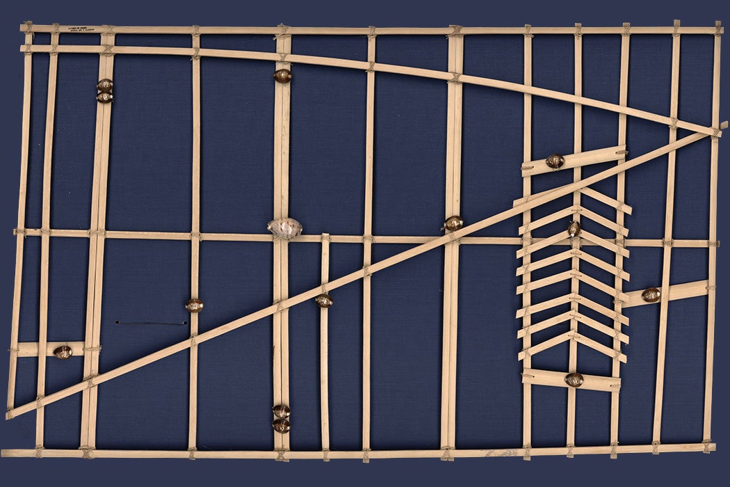
Can you read this chart? It may look like a wonky lattice, but to those trained in its meaning, the delicate curves and parallel lines speak of ocean waves and sandy beaches. This is, in fact, a wave chart, a navigation tool used by master navigators of the Marshall Islands.


Navigators in the Marshall Islands faced a unique challenge. The tiny islands and coral atolls they traveled between are mostly too low and small to be seen from more than ten miles away, so voyaging meant finding one’s way through a seemingly featureless expanse of open sea. If you were just a little bit off, you might completely miss your destination.
Faced with this challenge, islanders developed an ingenious solution: navigating by the feeling of the waves. This uniquely proprioceptive mode of navigation required the navigator to remain constantly aware of the motions of ocean swells coming from four directions. The eastern swell was the strongest, which allowed them to orient themselves.
They could detect the way a swell would change when it wrapped around an island or bounced back against a cliff, for instance. These distinctive patterns could be followed to land in the same way “the root, if you follow it, leads to the palm tree.” This is the mental model that the wave charts reflect: they show the sea as a kind of spiderweb, full of communicative tremors.

Wave charts aren’t maps so much as mnemonic devices. They’re not brought on board in order to navigate; rather, the navigator makes them as a personal reference, studying them while on land and bringing that knowledge onto the sea. There were a few different kinds: rebbelib, which represented whole island chains; meddo, which showed ocean swell patterns in a smaller area; and mattang, simple teaching tools used to diagram the basic interactions between land and sea.
While this particular mode of proprioceptive navigation was unique to the Marshall Islands, navigators throughout Micronesia and Polynesia used swells to orient themselves, along with other methods. To those who knew how to read it, the sea is full of signs: driftwood gathers at convergence zones; specific birds appear only near land; distant forests cast a greenish tint on the underbellies of the clouds above. As they traveled, songs helped to keep time, remind the sailors of important landmarks, and confer ritual protection on the voyagers.
Attending to all of this took a toll on the navigators. As the anthropologist Paul D’Arcy wrote in People of the Sea, “They say you can tell the experienced navigators by their bloodshot eyes.” Yet this level of expertise made possible a vast trading network across the Pacific Ocean, stretching at some points all the way from New Zealand to South America.
Weekly Newsletter
"*" indicates required fields
Gaining a full understanding of traditional navigation took years of intensive study. As Anthropologist Joseph Genz reports, in the Marshall Islands, young navigators would be trained by a kind of simulation. Wearing a blindfold, they would lie in a canoe while their teacher towed them around a shallow area of water. In just a few feet of water, writes Genz,
the apprentice learned to determine his location around this circular reef based on how the intersections and reflections of incoming waves from the ocean and lagoon affected the motion of the canoe. The reef models a destination atoll and the motion of the near-shore wave patterns models that of ocean swells flowing from the east and west. The magnitude of these sensations of movement at the dekä (miniscule!) are scaled up in the navigator’s mind in preparation for ocean voyaging.
In the 1950s, one such apprentice, Korent Joel, had begun this training in traditional navigation when he was displaced by the nuclear tests being conducted by the United States on Bikini Atoll. The fallout spread to his home island, bringing radiation sickness with it; his family was displaced, his training cut short.
Decades later, he returned to complete the voyage that would make him a master navigator, bringing with him a team of researchers to document the process. He succeeded and went on to train a new generation of traditional navigators before passing away in 2017. The knowledge lives on.


._LOC_2010586181.jpg)