Maps are often assumed to be faithful representations of reality, a straightforward spatial visualization of where things are in relationship to each other and a guide for getting from one location to another. Maps do this, but they also do much more. They can structure power, construct identity, and shape movement through a landscape. No map can reveal all the complexities of reality, so mapmakers inevitably make choices about what to include on the map and what to exclude, drawing attention to the spatial relationships that mostly serve the goals of the mapmaker.


The Ancient East Asian Maps collection from Lee Shau Kee Library at Hong Kong University of Science and Technology (HKUST) provides beautiful examples of East Asia’s premodern cartographic traditions. This collection contains thirty-eight maps produced in China and Japan from the twelfth to the nineteenth century and includes maps of the world, empires, nations, provinces, and even celestial bodies.
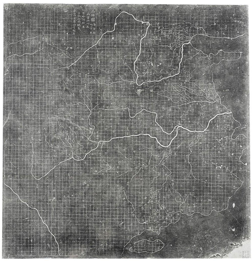
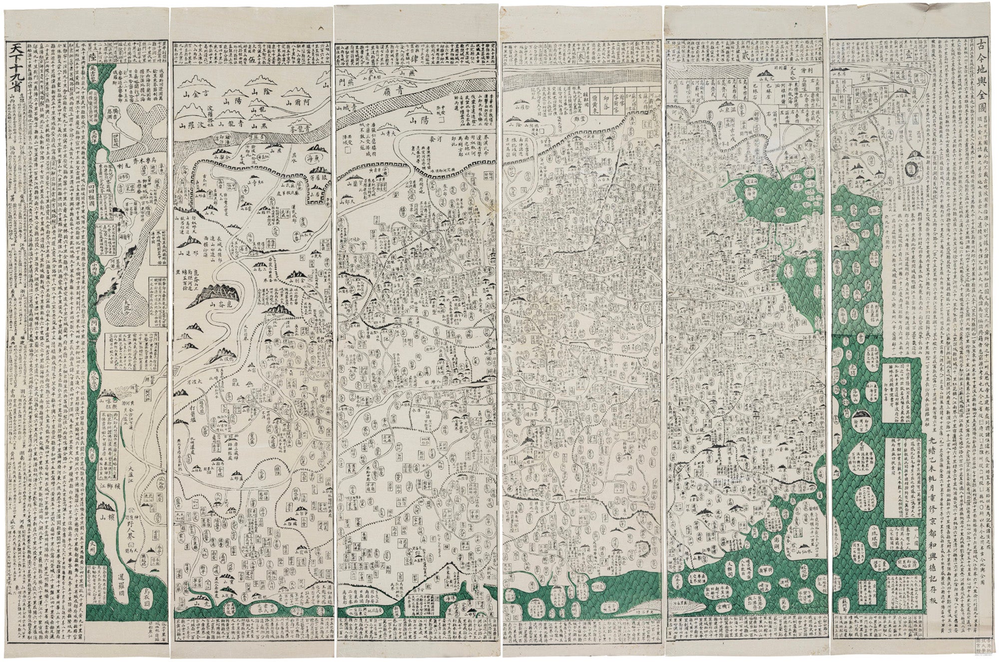
The earliest is “Map of the Tracks of Yu” (Yu ji tu 禹跡圖), which was engraved on a stone stela in 1136 and reveals cartographic accuracy far surpassing that of the contemporaneous West. The collection also includes historical maps, like the “Complete Map of the World, Past and Present” (Gujin diyu quantu 古今地輿全圖, created in 1895), which collapses chronological distance as it layers three thousand years of history onto a single map of Chinese territory, affirming a developing sense of Chinese nationalism that was tied to a territory and transcended dynastic iterations. The greatest number of maps in the collection are provincial maps, which provided useful information for new officials assigned to serve in unfamiliar lands. These provincial maps were regularly compiled by the imperial court to create comprehensive “unification” (yitong 一統) maps of the entire empire, several examples of which are included in the collection.
In addition to approaching these maps with the scientific values of modern cartographers, one can also approach them as a historian, examining what they reveal about the values, power structures, and identities of the people who made them. Let us situate these maps within their unique historical contexts and identify the cultural work that they accomplished in their own time. To provide an example of the power of maps, I would like to examine in closer detail the world maps in this collection. We will see how world maps reveal much about identity, knowledge, and power during different periods of East Asian history.
The isolationism and ethnocentrism of Chinese civilization is often overstated. It’s true that in its earliest history, Chinese civilization only encountered less technologically advanced peoples on its immediate frontiers, societies that lacked writing and state-level organization. For this reason, it was not unreasonable for early Chinese writers to imagine a world in which they were the cultural and political center, the “central realm” (zhongguo, sometimes translated as the Middle Kingdom) toward which all peoples should look for a model of civilization. But beginning as early as the Han period (202 BCE–220 CE), diplomats, merchants, and missionaries began to traverse the Silk Roads through Central Asia. They returned to China with information about civilizations of equal complexity to that of China. For example, reports came back of a mighty Roman Empire in the distant west, which the Chinese called the Great Qin State (da Qin guo 大秦國), a recognition of its similarities to China’s Qin dynasty (221 BCE–208 BCE) that preceded the current dynastic state. (Ironically, Qin is also what China became known as in the West and is the origin of our English word “China.”) But the distance of these civilizations and the limited intelligence about them allowed China, for the most part, to dismiss these as still “barbarian” lands and maintain their self-image of centrality in the world.
The first great challenge to this sinocentric vision of the world came with the widespread adoption of the Indian religion of Buddhism into China from the fourth to nineth centuries. The sophistication of Buddhist thought and the detailed geographical information about India brought back to China by Buddhist pilgrims made it quite difficult to dismiss India as a mere barbarian periphery. According to Buddhist scriptures, the inhabited lands of the earth were all on a tear-shaped continent called Jambudvipa. This worldview was adapted and presented to Chinese audiences most successfully by the seventh-century monk and pilgrim, Xuanzang 玄奘 (600–640), who recorded an account of his travels to India in a work known as Record of the Western Regions (Xiyu ji 西域記). As he described it, at the center of Jambudvipa was the great mountain Avanatapta. To the south was India, to the west, Persia, to the north, the nomadic steppe, and to the east was China. As Tansen Sen points out, in this world model, China was an eastern land, on the distant periphery of the Buddhist ecumene with its center in India. Although the Chinese imperial court continued to affirm a sinocentric worldview that legitimized imperial assertions of universal rulership, Nobuo Muroga and Kazutaka Unno make clear that the Jambudvipa worldview continued to be the primary alternative world model in East Asia up into the early modern period.
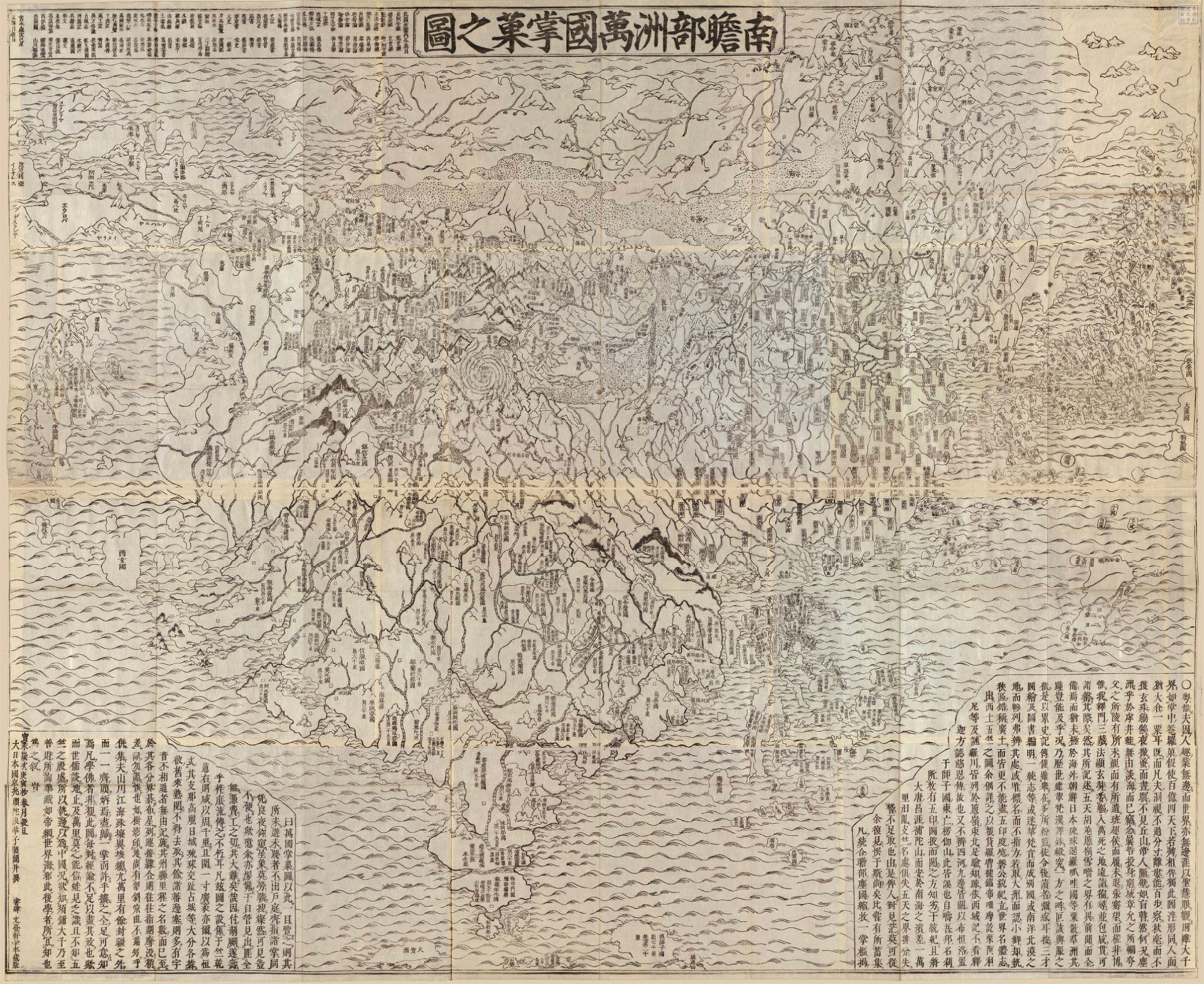
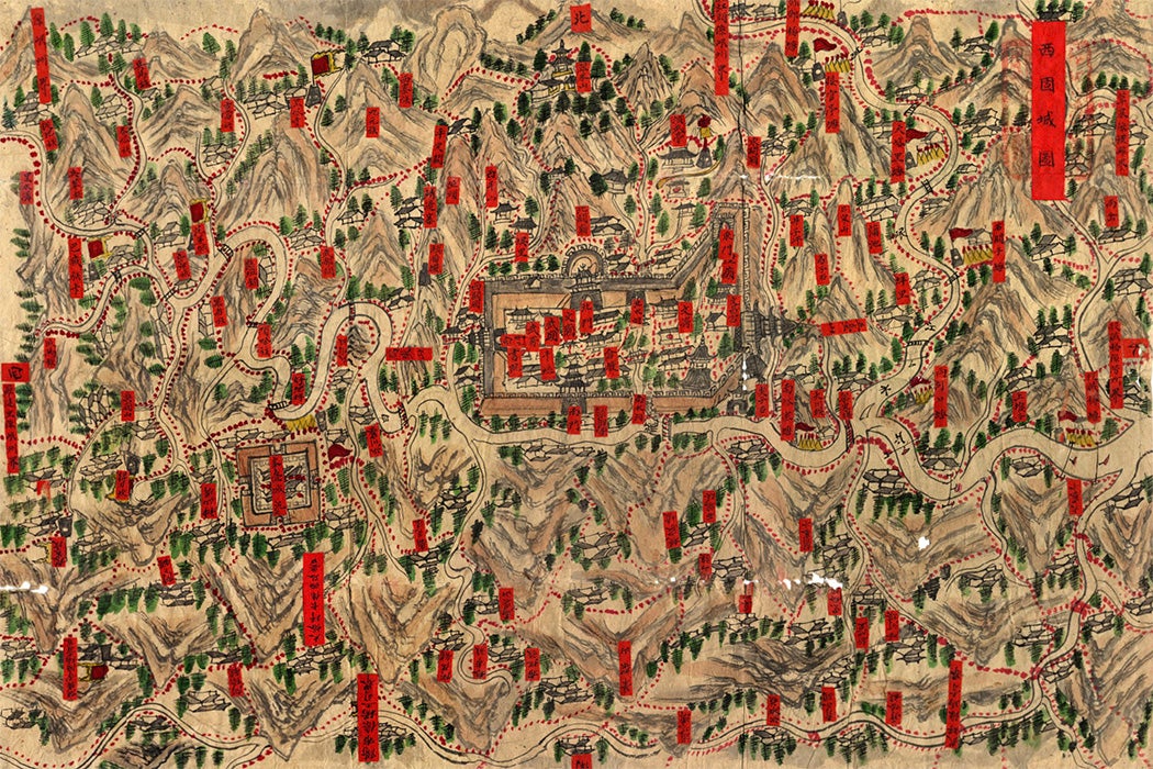
An excellent example of these Jambudvipa maps in the HKUST collection is the “Handy Map of the Myriad Lands of Jambudvipa” (Nansenbushū bankoku shōka no zu 南瞻部洲萬國掌菓之圖) printed in Japan in 1710. Maps like this were the mainstream of world printed maps in Japan until the middle of the nineteenth century, write Muroga and Unno. Mount Anavatapta surrounded by swirling rivers and high mountains is situated visibly in the center of the tear-shaped continent. India fills the largest quartile toward the south, China a little smaller in the eastern quartile. The continent extends westward to include the lands of Transoxiana and Persia and northward to include a horizontal strip of the Central Eurasian steppe. (The Roman empire (da Qin guo) is placed on an island to the immediate west of the Jambudvipa continent.)
This is all characteristic of Jambudvipa maps as described in Chinese sources from medieval times. Chinese sense of displacement from the center is all the more evident when this Jambudvipa map is transmitted to Japan, at the eastern periphery of China, which was itself at the eastern periphery of India, the homeland of Buddhism. To compensate for this sense of displacement, Japanese cartographers magnified the size of the Japanese archipelago, making it about half the size of China’s territory. Even more noteworthy is that this 1710 map is the first Jambudvipa map to incorporate European geographical information. Europe is included as a series of small islands in the northwest corner of the map, and South America is presented as an island just south of Japan—about a quarter of the size of Japan. This one map encapsulates a long history of Buddhism and the Buddhist worldview as it was transplanted from India, to China, to Japan, at each step attaching more information about the larger world to this ancient Indian world model, and at each step articulating new notions of cultural identity and one’s place in the world.
Weekly Newsletter
"*" indicates required fields
The second great challenge to the sinocentric world model came in the sixteenth and seventeenth centuries as European merchants, diplomats, and missionaries arrived in China, bringing with them information about the previously little known lands of Africa and Europe and the entirely unknown lands of the Americas. The Jesuit missionary Matteo Ricci (1552–1610) believed that a good way to convince Chinese of Christianity’s superior understanding of heaven was to prove to them Europe’s superior understanding of the Earth. He presented to the Ming court in 1584 a map of the world, with five continents, structured with lines of latitude and longitude. Subsequent editions of the map by Ricci were published, replicated, and circulated widely throughout East Asia. This new “five continents theory,” as the European world model became known in China, again displaced China from its traditional centrality. It also minimized Chinese territory into one small part of a much larger world and introduced quantitative cartographic techniques to attest to its veracity.
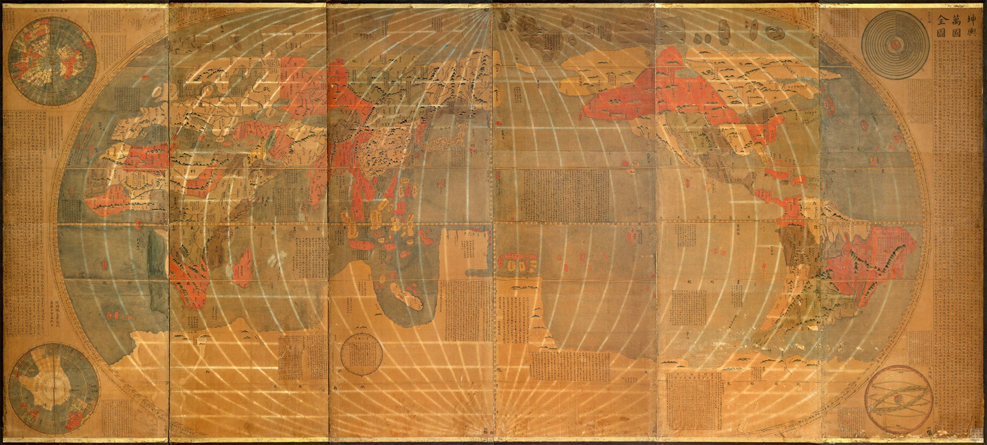
“Complete Map of All the Countries of the World” ((Ch.) Kunyu wanguo quantu, (J.) Konyo bankoku zenzu 坤輿萬國全圖, 1680) contained in the collection at HKUST is a modified version of Ricci’s map. The intellectual development of this map reveals both acceptance and accommodation from Chinese and Japanese intellectuals. Ricci’s map was originally based on Abraham Ortelius’s Theatrum Orbis Terrarum (1570), but Ricci rotated the longitudinal perspective so that China moved from the right-hand edge to at least somewhat close to its center. In 1602, Ricci produced a third edition of his map, in which he incorporated some elements of Chinese mapmaking traditions. He added to the map geographical information from Chinese sources about East Asia, and, building on the Chinese tradition of presenting map and text together, he added inset diagrams and marginalia to explain Western cosmology to Chinese audiences. These explanations utilize traditional Chinese terminology and concepts in order to facilitate understanding. The 1680 version of this map held in the collection is a later Japanese adaptation of this map, to which was added phonetic katakana symbols on the sides of the Chinese kanji that were already being used to render the names of foreign countries. This map moved around the world, and each new edition was modified to make it comprehensible and useful to each new audience within their distinct historical setting.
As with the Jambudvipa and Five Continents world maps, other maps in the collection connect knowledge and power. They assert and undermine authority; they defend, challenge, and reevaluate identity. They were instruments of religious conversion, and they were tools of political imperialism. Maps are powerful things indeed.