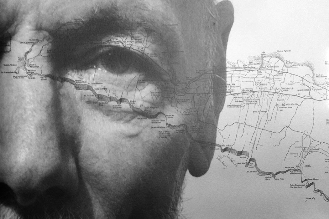
When the late mathematician and artist Tim Robinson moved to the island of Inishmore in 1972 to escape the London art scene, he started walking around the island. At twelve square miles, Inishmore is about half the size of Manhattan. Robinson got to know the jumble of limestone and walled fields, built up over centuries by people mixing sand and seaweed, by foot.


Noting Robinson’s growing familiarization with the island, the local post office superintendent suggested he make a map that islanders and tourists alike could use. Robinson and his wife, Mairéad, formed a publishing imprint called Folding Landscapes. The resulting maps, folded landscapes, were a hit.
But the more Robinson walked, “the more the complexity of the island grew—and the more he doubted the simple tropes that underlined the functional maps he had drawn,” writes the scholar Eamonn Wall.
“Clearly, there was more to a place than its roads, buildings, hills, and so on…. Landscapes, as [Robinson] points out, ‘cannot themselves be shown or named’—for the minimal language of maps, not to mention the problematic nature of language, are never quite pliable enough to convey the ineffable spirit of place.”
Indeed, Inishmore (Árainn Mhór in the Irish) may be small, but it is encrusted with human history, written over with names, rich with dinnseanchas, the Irish for “lore of place.” A paper map would soon be incomprehensibly scribbled, unless it was, as in Jorge Luis Borges’s famous short story “On Exactitude in Science,” the same size as the place it attempted to document.
Robinson died in April of coronavirus at the age of eighty-five. He wrote two books about the Stones of Aran, detailing his walks around and into those rocky fastnesses. Later, moving to Connemara on the Irish mainland, he mapped and wrote a trilogy about his explorations in that region, one of the largest Gaeltacht (Irish-speaking) parts of the nation. He also mapped and wrote about the Burren, the unique karst landscape in County Clare.
Combining, for starters, anthropology, linguistics, history, folklore, geology, and natural history, Robinson’s work is celebrated and renowned in Ireland. His books are starting to make inroads in the United States, particularly among cultural geographers, as exemplars of deep mapping. “Deep mapping” comes from William Least Heat-Moon’s PrairyErth (1991), a thick exploration of Chase County, Kansas. Least Heat-Moon’s “the least I hoped for was a topographic map of words that would open inch by inch” is akin to Robinson’s approach.
Weekly Newsletter
"*" indicates required fields
Cartography’s origins lay in surveying ownership and conquests. But there have always been alternatives. Wall touches base with Herman Melville’s famous line “It’s not down in any map; true places never are.”
Tools for commerce dominated by roads, the digital maps on your device are ways to get somewhere without experiencing the space you travel through. Tim Robinson spent decades walking over parts of western Ireland, mapping the land he walked, learning about and writing its history, from the geological to the genealogical—each step an accumulation toward a whole.