Poverty Point in Louisiana is a state historic site, a national monument, and a UNESCO World Heritage site—but it’s still probably better known to archaeologists than to the general public. And that’s a shame, because it’s the “largest and most architecturally complex Archaic site in North America,” writes archaeologist Anthony L. Ortmann in his analysis of the dating of the site.


The site dates back around 3,700 years, putting the first earthwork construction there in what’s called the Late Archaic period. This is “Pre-Columbian” by millennia. Poverty Point culture, as it has been named, extended across hundreds of square miles of the Mississippi Delta. It’s influence was felt much further: material found at Poverty Point suggests it was a center of exchange networks that stretched up the Mississippi and into the Ohio and Tennessee valleys as well as the Appalachian Mountains and even as far as the East Coast.
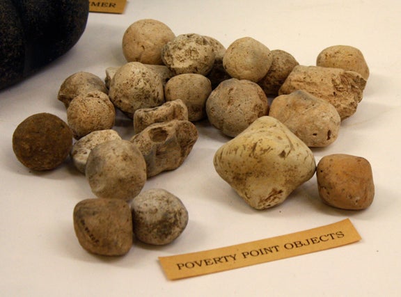
Among the most frequently found artifacts at Poverty Point are the unglamorously labeled Poverty Point Objects (PPOs). These are small baked ceramics (made of loess soil rather than clay) that were probably used in cooking. It’s surmised that they were added to ovens to cook foods by radiative heat. In a region without a lot of loose rock that could be used for cooking stones, the PPOs seem like a creative adaptation to local circumstances. The fact that there are so many of them suggests that there was a lot of eating at Poverty Point.
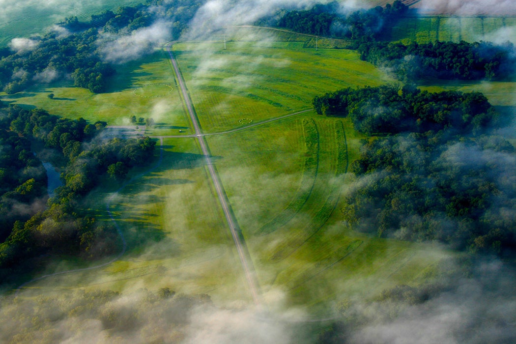
From the air, Poverty Point looks like a giant open-air auditorium. Including the debris from the centuries of building and rebuilding, it spreads out across about three square miles. A series (five or six, depending on your source; see below) of concentric, C-shaped earthen ridges surround one side of an artificially raised plaza. The sinuous Bayou Macon borders the complex to the east. Nearby are several large mounds, including one seventy-two feet high, while farther still are even more mounds. Many millions of cubic feet of soil would have been moved to create all of this, dug out by hand tools and carted away by basket.
Poverty Point has been envisioned as a “great town” and/or as a ceremonial center. As should be expected when the evidence is so limited, the purpose(s) and use(s) of Poverty Point are debated. There’s also debate about whether the site was the result of a master plan or grew up more spontaneously over generations. One thing is for certain: the assumed notion that fisher/hunter-gathers weren’t “sophisticated” enough for major construction projects has been discarded. The “Archaic”—in hindsight, perhaps an unfortunately chosen term—was a lot more complicated than originally thought.
And as it happens, Poverty Point isn’t only the most complex of the earthworks in the region. It’s also much younger than some of its neighbors. Gerry Powers provides a handy overview on the origins of mound-building in the region, all of which predate the better known mounds of Cahokia, Illinois, by thousands of years. For instance, the earthworks at Watson Brake, near Monroe, Louisiana, were revealed in 1997 to be the oldest known earthwork construction in North America. Initial construction at Watson Brake was 5,500 years ago, making it older than Stonehenge and the pyramids of Egypt.
The North American Archaic period spans seven thousand years. Until fairly recently, it was assumed to be pretty uneventful, as if human beings did nothing much for hundreds of centuries. That old view has been revised in light of the facts on the ground. And there are probably many more discovers to be made. Watson Brake, for instance, was almost leveled by loggers in the early 1980s. The site was only saved because a local woman put herself in front of the bulldozer.
Weekly Newsletter
"*" indicates required fields
The history of American pre-history is still being rewritten. As anthropologist Tristram R. Kidder notes, Poverty Point itself was only intensively mapped in 1999–2000. Previous mapping relied upon aerial photographs, leading to the confusion over the number of ridges. The mapping showed five ridges, not six as had been assumed.
So Poverty Point, which was named after a local plantation that came and went thousands of years after the first earthworks were developed, is still revealing its riches—and the meanings we give to them.
