Persuasive Cartography: The PJ Mode Collection is a physical and digital collection of maps donated to Cornell University Library’s Rare & Manuscript Collections. It brings together maps from many eras from all over the world to explore their power as visual messengers. The collection is freely accessible in Artstor’s public collections and through the collection’s website. Hannah Marshall sat down recently with donor PJ Mode to discuss the origin of the physical collection and some of the collection’s highlights.


Hannah Marshall: What is persuasive cartography, and how did you become interested in collecting it?
PJ Mode: Persuasive cartography refers to maps intended primarily to influence opinions and beliefs—to send some sort of a message—rather than to communicate objective geographic information.
I began collecting maps in 1980, I was in Paris and, almost by accident, I wandered into a wonderful exhibition at the Pompidou Centre. I was blown away by the exhibit; it was very interesting and very beautiful.
When I came back to the US I really thought, “Well I’m going to see if I can’t start acquiring some of these maps.” So, I began collecting old maps, and I focused—as many collectors do—on old maps of the world and the Americas. These were important maps, but they’re pretty expensive so, I put myself on a budget and decided that I would buy just one or two good maps a year.
Weekly Newsletter
When I was looking at those maps in dealers’ shops or catalogs, I often saw other maps that I thought were fun and interesting. I didn’t quite understand them all—unusual maps, strange maps of different kinds. The kind of maps that dealers refer to as “cartographic curiosities” (which basically means, “This doesn’t fit into one of my pigeon-holes…”). These were kind of fun and interesting, and they were inexpensive so, on a lark, I would buy them when I saw them and then I would kind of try to figure out what they were.
After a while, I became more and more interested in those and started looking for them. Eventually, I started to ask myself what it was that interested me about those. I came to the view that, what really interested me was that they were pieces of advocacy in one way or another. I would now use the term “persuasive.”
A lot of my collecting has to do with intellectual curiosity. Every map has its own standard bibliography: Who made it? What’s its title? When was it made? Where was it made? Who published it? Every map is a sort of Who, What, Where, When. The maps I’m interested in have another question, and that’s: “Why?”
Do you consider the collection to be particularly strong in one area or another? When you’re collecting, do you think about how a map will fit in and relate to the rest of the collection and how it would interact with other maps in a subject area?
I hesitate to use terms like “strong” and “weak” because a lot of it depends on how much material there is available. So, I would say there are areas where I think I have a lot of material. That’s particularly true for the second half of the 20th century, and a lot of that is because there’s just a lot of material available.
I have a lot of German material from the time between the wars, and that’s a very important time for persuasive cartography because the Germans were really good at it and published a lot of interesting and effective cartographic material. I also have a lot of WWII material from all over the world: the US, England, the Netherlands, France, Germany, Japan. Again, that’s in part because a lot of it is skillfully done and readily available.
A lot of my collection is ephemeral—some of it comes out of books and atlases, but a lot of it comes from pamphlets, magazine, broadsides, handbills, and posters.
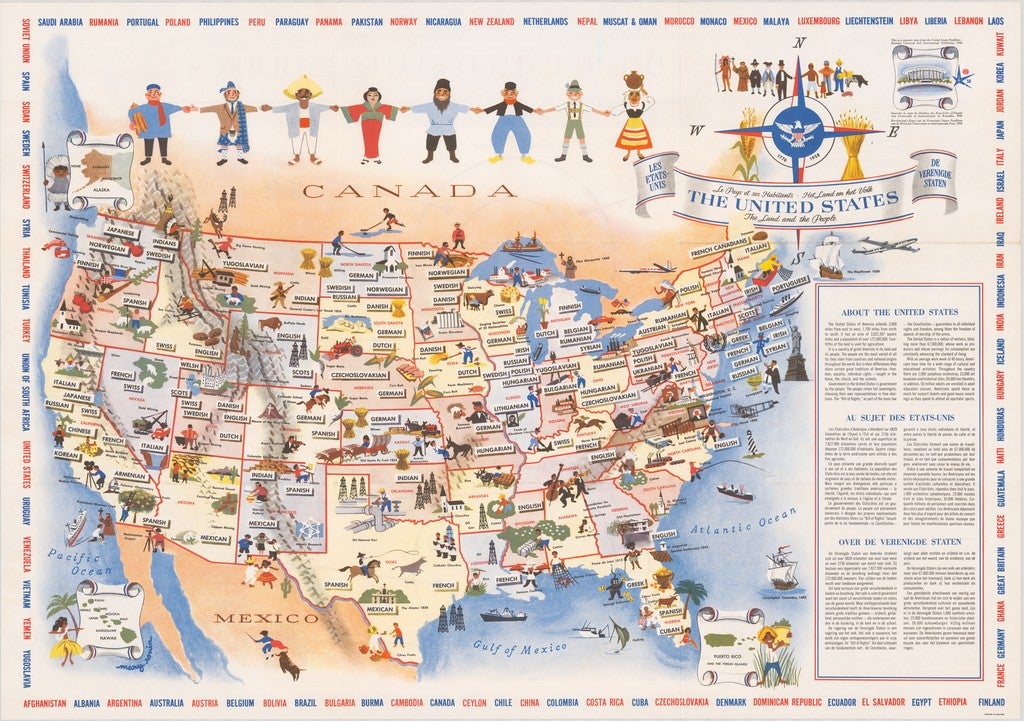
Now, I’m hesitant to buy more material in areas where I have a lot, but if it’s a really good fit, I’ll pursue it. For example, in an auction next week there’s a Russian counterpart to an American map I own that was created for the 1958 world’s fair in Brussels at the height of the Cold War. The American one is a beautiful map put out during the Expo advertising the US as a land of many different people. In the auction next week, one of the things that’s for sale is a similar map that the Russians put out for the fair that includes a map of the Soviet Union, but instead of having people on it, it depicts heavy industry, the power plants and things like that.
This material is challenging and unique in terms of how it can be categorized and presented. What were your goals for building this as a digital collection?
At the time of purchase, I do a fair amount of research about what I’m buying. And, as you can tell from the collector’s notes, I sometimes do a lot of research. At some point I thought, “It would be nice to be able to make this information available to people.” The other thing has to do with the images themselves. As the internet matured, I began to see that a lot of my collection was unique and for many of my pieces, I couldn’t find other known copies or, if I could, there weren’t images available.
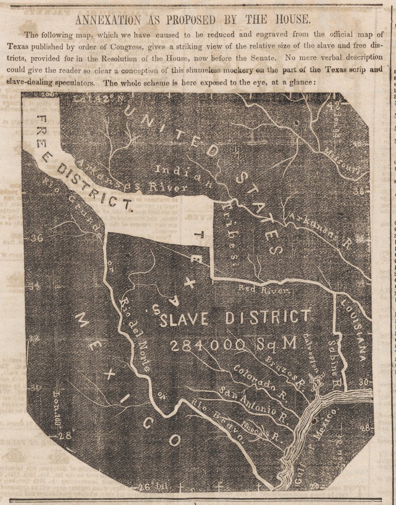
This map appeared in the Newark Daily Advertiser on February 11th, 1845 while Congress was in the process of adopting the legislation that annexed the state of Texas. A lot of abolitionists were violently opposed to the annexation of Texas on the grounds that it was going to spread slavery to the West. This map appeared right as the House had adopted the resolution and the Senate was considering it; it was meant to rile up the readers. This is a unique map with no antecedent—I’ve been in touch with collectors who specialize in Texas maps and the staff at University of Texas Arlington, where they have the world’s largest collection of Texas maps, and no one has ever seen this map before. This is the only known copy.
There must be copies of the newspaper itself on microfilm somewhere, but this is the only known physical copy.
So, as time went on, I began to think about ways for me to share these materials. As I got near retiring, I began to think about what to do with the collection: I thought about writing articles or a book or mounting an exhibition, but it occurred to me that putting the maps online would be a good thing to do. I was then further inspired to do so by David Rumsey, a San Francisco map collector with a collection of over 100,000 maps now housed in a map library bearing his name at Stanford, of which he has put 75,000 online. Through mutual friends, I met and became friends with him and he had great advice and really encouraged me to put the collection online.
How have you felt about the reception of the digital collection?
I’ve felt really good—after the first batch of maps went up the collection got attention on certain blogs, and then when we published Phase II it got a huge reception—the website has gotten a lot of hits. And, interestingly, the people who visit the site stay for long enough to browse and think about the content.
I heard from a geography professor who, for one of his classes, had assigned his students to go look at my website and pick a map that interested them and write about it. I’ve heard nice things from collectors and dealers, including dealers who cite the collector’s notes on my site.
The site makes the maps available for anyone to access and reuse the images for any non-commercial purposes, so this is not a situation where anyone who wants to use the maps has to write and ask for permission but, nevertheless, I hear from people all over the world who are interested in using the images on websites, in courses, in exhibitions, in publications.
![Ocean-Chart [The Bellman’s Map]. 1874. Persuasive Maps: PJ Mode Collection](https://daily.jstor.org/wp-content/uploads/2019/08/persuasive_cartography_4.jpg)
So I go on my computer and write up that a “Snark hunter” from Munich has made clear that the map was not done by Mr. Huntington and I changed the mapmaker to “unknown” and I updated it.
There are so many things about that interaction that just would never have happened if it were a physical collection or if you had gone the route of writing a book or curating an exhibition.
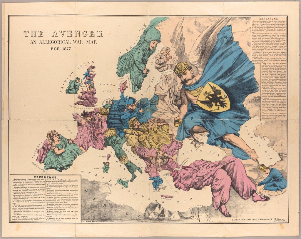
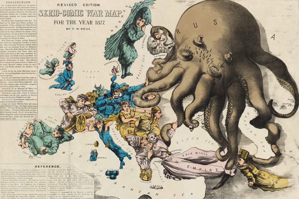
I’ve got another great example of that: The map “The Avenger: An Allegorical War Map for 1877.” It’s anonymous, there’s no mapmaker listed, but it’s always been attributed to a mapmaker named Fred Rose for various reasons. When I posted this originally, it said Fred Rose had done this and cited a source. Then last year two map dealers and scholars, Ashley Baynton-Williams and Roderick Barron, each published articles completely debunking the notion that Fred Rose could ever have done this map. It was very authoritative; they’re clearly right. I read these articles and changed the Collector’s Note for the map.
That level of participation and interaction is unique to the digital environment.
Exactly. My goal here was simple: I think this stuff is really really interesting and I wanted to make it available to anyone else who thought it was interesting, and to do so on as wide a basis as possible. I put a lot of time and energy into my research, and I find it really fun, but having created a fair amount of intellectual property, if I could make that available to somebody else, I’d like to do that.