Early European colonists in North America tended to describe the continent’s Indigenous people in terms derived from European experience such as “nation” or “country” or with the biblically derived word “tribes.” For example, seventeenth-century French maps might designate areas outside colonial control with terms like pays des Outaouais or pays des Miamis, or, more broadly, pays des sauvages.


Looking at historical records from people of the Plains region, particularly one 1805 map, anthropologist Raymond DeMallie and historian Gilles Havard argue that this kind of language obscures the way “Indians” thought of their own social and political groupings.
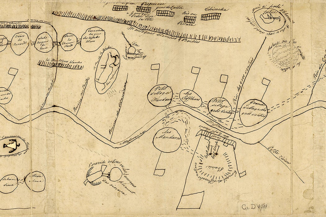
In 1805, a leader of the Arikara people, known as Village Chief, drew a map to explain the area he was familiar with to Euro-Americans. The drawing centers on the Missouri River.
Rather than showing the entire area divided up among different groups in the fashion of European nation-states, Village Chief used small circles to indicate various groups in terms of their geographic relationship to each other and to waterways. Dashed lines between the groups indicate connections. For example, dashes unite five circles representing groups within the Sioux alliance. Dashed lines also connect three Arikara villages with the council ground where members of those villages met with the Lewis and Clark expedition. The map also shows Arikara hunting grounds and wintering places, located west of the villages.
Significantly, the circles represent specific villages or nomadic bands, not tribes or nations. DeMallie and Havard write that, for people living along the Missouri River in fixed earth-lodge homes, the village was the most significant grouping. In addition to their local homes and farm fields, individual villages also had much larger designated areas that might be shared with other groups for hunting in the summer and fall and for religious activities.
More to Explore

Trees With a Secret Message
The map includes only two European settlements, Santa Fe and Fort de la Compagnie du Nord-Ouest. Many Europeans, chiefly men of French heritage, lived in the region outside those places. However, they were generally integrated into Indian communities and often married to local women—an example of a general dynamic governing these societies’ relationships with Europeans and their culture.
“At this time, Indians did not become Europeanized,” DeMallie and Havard write. “They integrated European manufactured goods into their local economies but adapted them for their own purposes and in their own ways. Village Chief’s map vividly portrays his world as overwhelmingly Indian.”
Weekly Newsletter
If the most relevant social-geographical grouping might be narrowly defined as a village, it could also be understood much more broadly. In 1932, when a Hidatsa elder named Bear’s Arm was asked to draw his village’s past territories, he included much of the state of North Dakota—an area used for hunting and daily life by the Hidatsa as well as other groups, including both allies and enemies.
It was only with the Fort Laramie Treaty of 1851 that Plains nations began identifying their lands as contiguous, mutually exclusive territories—and also designating an executive head chief empowered to sign agreements with the US government and other Native nations.