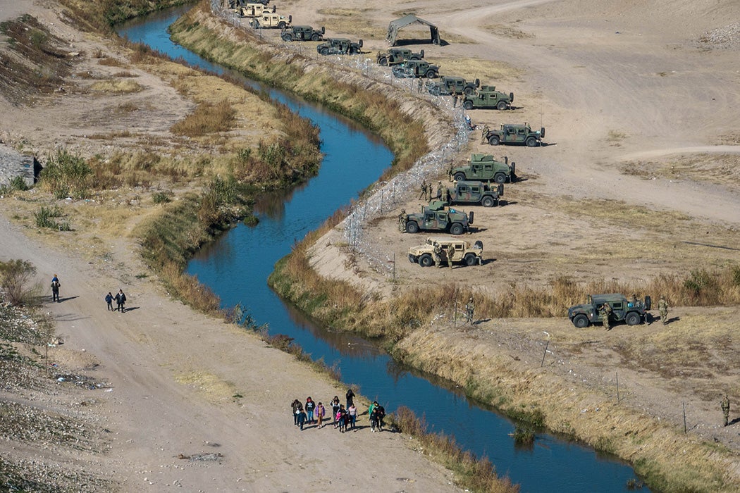
Nature abhors a border. Take the Rio Grande, which since 1848 has been the border between a large part of the United States and Mexico. As a river, its very fluidity makes it difficult to pin down. Overtopping its banks in flood, willfully changing its course, meandering without any regard for imaginary lines written across terrain, water presents a serious problem to those who police those imaginary lines.


“Up until the 1930s, the governments of the United States and Mexico permitted the river to ‘meander’ through the alluvial flats of the border region,” writes environmental historian C.J. Alvarez. “The waterway had dozens of bends and twists that would be completely unrecognizable to anyone familiar with the border today.”
This loose winding river posed two problems in the West Texas–Northern Chihuahua region. Its “shifting course created uncertainty as to the exact location of the international divide” watched over by the joint US–Mexico International Boundary Commission. (The IBC changed its name to the International Boundary and Water Commission in 1944).
Flooding was the other problem, both for the area’s farmers and for the people living on both sides of the mirroring cities of El Paso and Ciudad Juárez.
As a result, a “rectification” plan largely designed to safeguard US agricultural interests straightened the river through the 1930s with large earthworks. All told, 155 miles of winding river were straightened down to 88 miles by the project’s completion. “Sixty-seven miles of river were simply removed.” The effort to make sure neither the US nor Mexico lost overall territory in the process saw 5,121 acres “ceded back and forth between the two countries.”
Thus straitjacketed and stabilized, the Rio Grande became a lot easier to police. Instead of twists and turns, murk and muck, the border became a clear-sighted earthwork-encased channel. As Alvarez shows, this was recognized from the beginning of the project, with the American IBC commissioner writing (for public consumption) that it would lead “to more satisfactory enforcement of the immigration and customs laws.”
“Border policing and hydraulic engineering” turned out to be “mutually constitutive.” As Alvarez argues, the meshing of border policing and engineering projects during the first half of the twentieth century were major components of the effort to harden the border.
More to Explore
The Treaty of Guadalupe Hidalgo: Annotated
At the same time, the massive hydraulic projects that made the arid West bloom in places like “the San Joaquin and Imperial Valleys of California, South Texas, the Salt River and Casa Grande Valleys in Arizona and elsewhere,” created “a sustained demand for cross-border migrant labor.” Big Ag was made on the flow of government water projects—and the flow of migratory labor, government-sanctioned (as in the Bracero Program, 1942–1964) or not.
Alvarez also analyzes the construction of the first large-scale border fence. This was done over 237 miles of the 674 miles of land between the Pacific and El Paso–Ciudad Juárez, where the river becomes the border. Most of this construction took place after 1948, “propelled by concerns about a foot-and-mouth disease outbreak in Mexico in 1947.” But, as with the All-American Canal, an 82-mile-long aqueduct parallel to the border completed in 1942 to move Colorado River water to the Imperial Valley, “law enforcement enlisted it into the project of interdiction.” Interdiction of humans, that is, not quadrupeds.
Weekly Newsletter
Alvarez also revisits Falcon Dam on the eastern end of the Rio Grande. This was constructed in the early 1950s for flood control, irrigation, and hydropower. It was also constructed as a border crossing. At its dedication in 1954, President Eisenhower called the joint project a testament to “two peoples” living in harmony. That same year, Eisenhower’s West Point classmate, Joseph Swing, Immigration and Naturalization (INS) commissioner, put “Operation Wetback” into operation, deporting more than a million people south across the border.
“In a single generation, the thirty years between 1924 and 1954, the built environment of the border changed radically to match the increasing authority of the Border Patrol and the IBWC,” writes Alvarez. The premise “that physical construction could be a central means of effecting control over other people as well as the nonhuman world would continue to evolve as one of the most definitive aspects of border history.”