Maps from the distant past look nothing like the world as we imagine it today. They guide us not through space but through time. A world map from the eleventh century promised people alive in the eleventh century the chance to peer into distant, exotic lands; looking at the same map today affords a glimpse into a distant time, a chance to see through the eyes of people who lived and died more than 900 years ago.
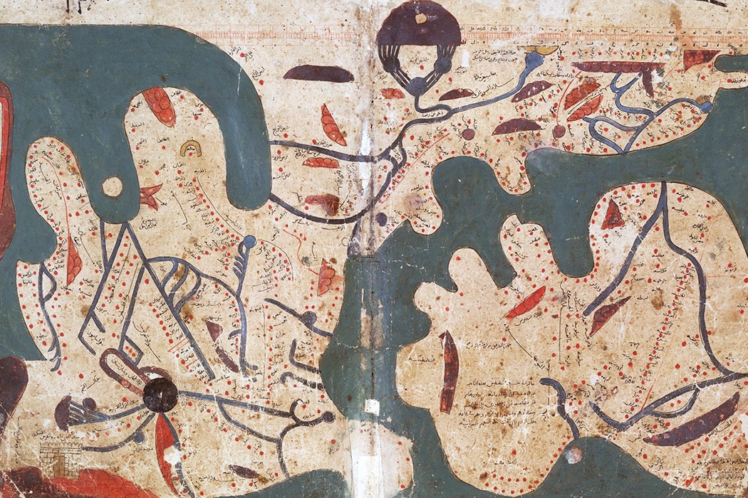
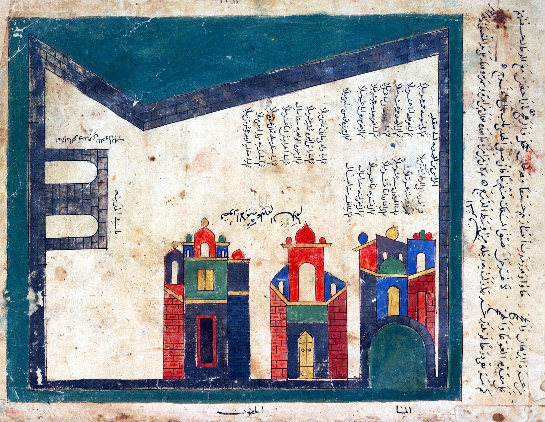
Take The Book of Curiosities of the Sciences, and Marvels for the Eyes, an eleventh-century Arabic geography compiled by an anonymous scribe. Despite the wear of centuries, the book is still a wonder. Its illustrations are designed to excite the senses as well as the intellect. Waters painted with silver to make them shimmer; comets that blaze with flakes of gold; lapis lazuli deepening the ocean’s blue. In those days, paper was an expensive commodity, such that the book’s wide margins were a show of lavish excess.
Its exquisite world map, one of the first of its kind, looks bizarre to a modern eye. At first glance, the land masses seem like formless blobs. But flipped upside down, reversing north and south, the wiggly blobs at the bottom resolve themselves into the Italian and Iberian peninsulas. England is shrunken to a faint speck, while Sicily is swollen and plump. Africa has been twisted into the shape of a sickle, and the frilly coastlines of Russia and China have been sanded down to a smooth arc. A band of indigo ocean encircles the continents.
There is a philosophy underlying the geography. It pins abstract concepts to points in space, placing civilization and order at the center and wilderness and chaos at the edges. The medieval Arab world inherited the Greek conception of geography—in particular, that of Ptolemy, who separated the world into seven climates. The concentric arcs marked on the map represent these climates. The world is mapped as a circle with a center and a periphery; the regions grow hotter to the south and colder to the north, buffeted by different kinds of winds on the eastern and western sides, while the land at the heart of the map enjoys a harmonious balance of elemental forces. The people living at the center benefit from the temperate weather and grow up beautiful and healthy.
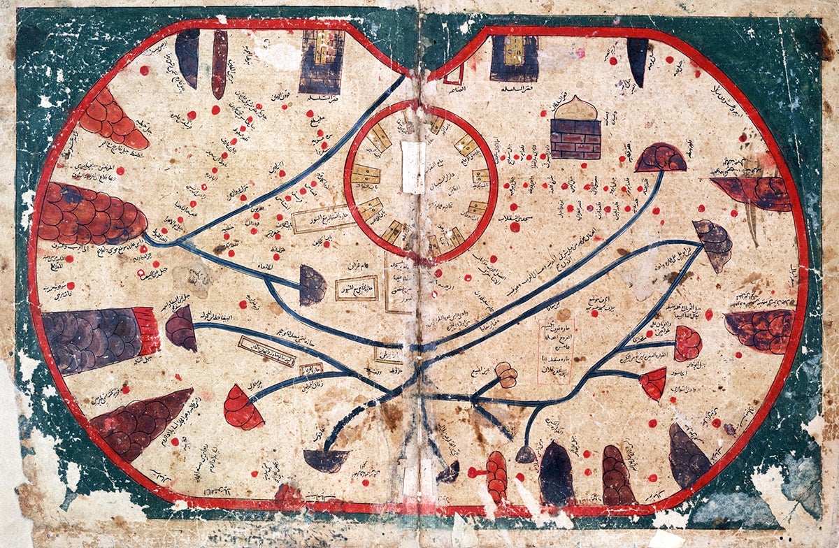
The cartographers reinforce this idea of the center as normal by placing monstrous outliers at the edge. There, the inhabitants’ bodies are distorted by heat, cold, or the ravages of harsh winds. Extremes of climate produce extremes of life, creatures that are huge or tiny or twisted or just plain weird. The further you go, the more things grow monstrous and wild.
The world map prefaces the section entitled “On the Cities of the Remote Regions,” beckoning the reader outward, away from the familiar and into the exotic. The westernmost edge of the map is marked by northwest Africa. There, according to The Book of Curiosities, fabulous wealth is matched by grave danger; gold lies uncovered in the sand, but guarded by ferocious inhabitants. The air is so thick and hot that the light of dawn filters through as if through a dirty window. Strange creatures proliferate: monstrous humanoids that speak in whistles and a creature called the irbid that, after having sex with a human being, breaks in two and dissolves.
The beings that inhabit the remote regions are monsters because they are hybrids, transgressions of the border between human and animal. There are strange unclassifiable creatures who dress in leaves and speak in chirps, mermaids whose language is laughter, fish with human faces that fly above the water, men who graze like cattle, and people with faces in their chests or ears big enough to spread on the ground like carpets.
At the furthest edges, even the boundaries between human and vegetable begin to dissolve: On a distant island in the Indian Ocean grow the Waq-Waq trees, which bear fruits in the shape of plump, curvaceous women who constantly scream “waq waq!”
These distant lands are not just strange but also dangerous. Nightmares lurk at the edges of the map. On the easternmost border, a wall marks the separation between the outermost edges of human civilization and the wilderness of demonic creatures known as Gog and Magog. Gog and Magog have gray skin, scraggly hair, and fingernails like knives. Every day Gog and Magog scratch the wall down to a sliver, and every night God rebuilds it. In this way, the end of the world becomes not just a temporal but also a geographical reality, something that can be marked on a map. The apocalypse sits at the edge of the world, waiting for its day to come.
The map of The Book of Curiosities presages a much more famous one: the map designed in 1138 by master cartographer al-Idrisi for King Roger II of Sicily. Every known river and route, every island, every twist of the coastline was inscribed on a gleaming silver disk more than six feet wide, a shining circle on which the world was laid bare. Looking at the map, you would see simultaneously your own reflection and the geography of your world. The map is at once a mirror and a screen. It reveals both the world around it and the face of its creators.
There is an interesting legend that further illuminates the relationship between maps and mirrors. It comes to us by way of Ibn al-Zubayr’s Book of Gifts and Rarities, an eleventh-century record of the gifts exchanged by kings. Reading the record is like browsing through a dragon’s hoard: Ibn al-Zubayr writes of snakeskin rugs that protect their owners from disease, letters written in pearls pressed into camphorwood, ambergris, saffron, and kohl. But folded among these lists of luxuries is a seemingly incongruous story—an account of how the caliph Mu‘āwiya spared an enemy’s life in exchange for a shard of a broken mirror.
According to the legend, the mirror was a fragment of a magic mirror that God gave Adam, and its power allowed its holder to see anywhere in the world. Peering through the mirror was like looking through God’s eyes. Adam watched his descendants grow up, marry, multiply, and spread across the globe in the mirror’s surface. Through it, Mu‘āwiya spied on his generals and cheered his soldiers on in battle. The mirror reknit ties frayed by distance. Without it, Adam’s vast family might fragment into tribes, estranged from one another, and Mu‘āwiya’s army might turn against him, splintering into warring factions. By the time of Mu‘āwiya’s reign, the mirror had broken, and only a single shard remained. And by the time Ibn al-Zubayr was writing his chronicle, that shard had vanished forever.
The act of making a map is an attempt to re-create Mu‘āwiya’s magic mirror: a transparent window, an undistorted view of the world. But, in the attempt, the maker inadvertently creates a reflection of their own assumptions about the nature of the world. Like Mu‘āwiya’s disintegrating mirror, many of these old maps have been lost. Even the version of The Book of Curiosities that we have today is a copy made one or two centuries later. Yet for those few fragments we still possess, the power to open a window to the past remains. When future historians look at our maps and our accounts of the world centuries from now, what will our reflections look like?
