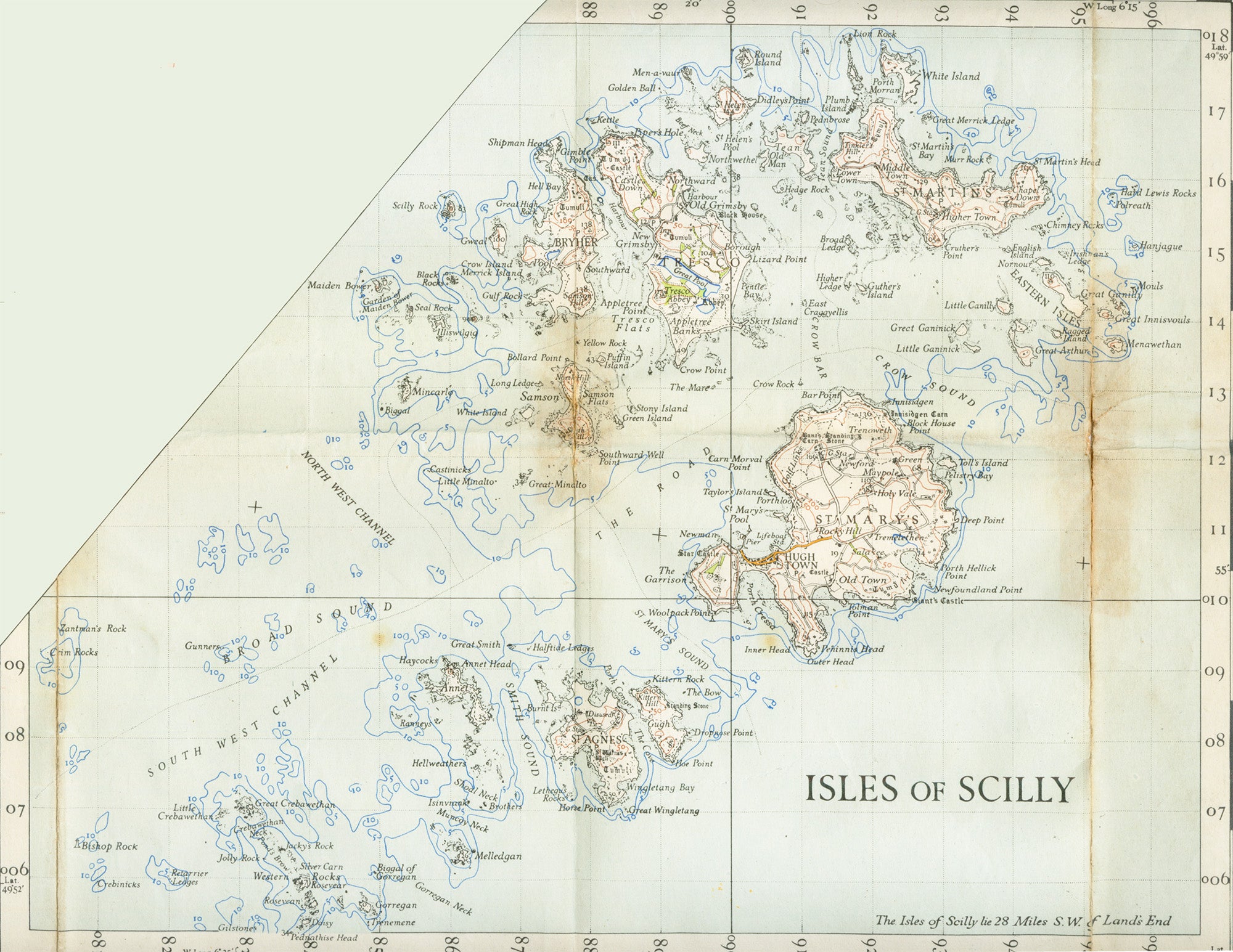
Just thirty miles off the southwest coastline of England lies an archipelago so small that it’s often left off maps of Great Britain entirely. The confusion to some outsiders continues even when it comes to pronouncing the name of this cluster of islands correctly. If in doubt, then be sure to remove the “c” so that the word rhymes with “‘hilly.”


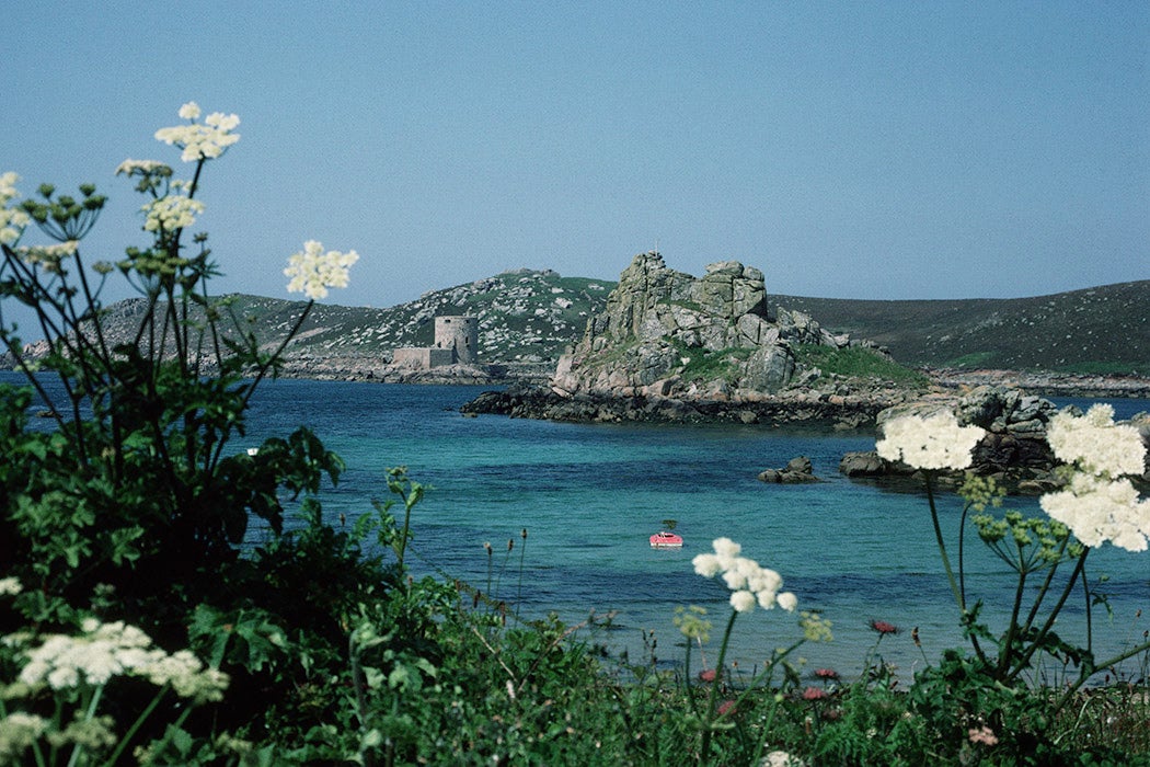
The Isles of Scilly are, politically speaking, part of the county of Cornwall. Even so, life there feels very different from the British mainland, with the five inhabited islands of St. Mary’s, Bryher, Tresco, St. Agnes, and St. Martin having a rich history all of their own.
That history dates to at least the later Mesolithic period (c. 6000–4000 BCE), when the islands supported at least seasonal human habitation. Trevor Kirk, in his chapter in the 2016 edited volume Decoding Neolithic Atlantic and Mediterranean Island Ritual, asserts that the landscape
was a mixture of oak forest, perhaps with localised clearance, some wetland areas suited to fowling, including open marsh which, by the mid-fifth millennium BC, may have also included some grassland. There is evidence of temporary and presumably episodic visits by hunter-gatherer-fisher communities during the sixth and fifth millennia BC.
It’s possible that hunter-gatherers were attracted to these remote islands due to the possibility of being able to trap fish in the coastal flats. What’s more certain is that, by the Bronze Age (c. 2500–800 BCE), the Isles of Scilly had become something of an “island of the dead.” As Katherine Sawyer writes in her 2015 book analyzing Scilly’s Bronze Age graves, “given the density of distribution of burial chambers in the islands, there is a temptation to regard Scilly as a prehistoric necropolis not only for islanders but also for people from elsewhere, whose remains were taken there for burial.”
Today, more than eighty entrance graves dating from the late Neolithic to the Middle Bronze period are known to exist across the islands, the clusters of rock slabs providing an eerie reminder to visitors of the island’s distant past.
Much later, the islands were one of the last strongholds where the Royalists held out against Oliver Cromwell during the English Civil War. Eventually, in 1651, the islands fell, though, as A. L. Rowse points out in his 1987 review of Norman J. G. Pounds’s book, The Parliamentary Survey of the Duchy of Cornwall, the effects of backing the losing side, coupled with the consequences of the earlier Reformation, were far from disastrous for the islands.
“The concentration of population upon St. Mary’s and Tresco is remarkable; other islands were depopulated,” writes Rowse, but “the overall impression one derives is that…tenants were in a favourable situation, their interests well considered. Everywhere their rights on the commons were assured, and these were important.”
True peril for island residents, and those who ventured too close to them by sea, came in the form of the lethal rocks that rendered the Isles of Scilly one of the most dangerous land masses to navigate in the entire United Kingdom. In 1707, the Royal Navy suffered one of its most deadly tragedies; at least 1,450 men died when six vessels, out of a fleet of twenty-one navy ships headed from Gibraltar to Portsmouth under the leadership of Admiral Sir Cloudesley Shovell, capsized after being driven into the cliffs.
“The only reasonable explanation for such a large navigational error appears to be that the fleet made more rapid headway than reckoned,” write William E. Carter and Merri Sue Carter,
either because the current they faced was weaker than normal or because gusty winds resulted in faster sailing speeds than were estimated. Admiral Shovell’s decision to try to make port immediately rather than wait for a more reliable determination of his position was simply foolhardy and cost 2,000 lives, including his own.
The disaster led to the British government launching the Longitude Act so that longitude at sea could be improved to within half a degree of accuracy, saving countless lives in the process.
Yet the islands have never been entirely besmirched by burial cairns and maritime disasters. A. Downes, in a 1957 essay, refers to the Isles of Scilly as the “Fortunate” Isles, due to a mild climate, rich soil, and the islands’ ability to grow flowers, which, even seventy years ago, were in demand all across the mainland.
“The flowers are hand-picked in bud to prevent wind damaging the flower and are opened or ripened in metal vases in the glasshouse,” writes Downes.
As [the buds] open they are taken to the packing shed, tied in bundles of a dozen blooms, packed in boxes of a dozen and a half to two dozen bundles, and sent by steamer, or occasionally by air, to Penzance for express despatch to London and Covent Garden market.
This romantic image of the islands as a hub of verdant and fecund retreat continues today. The Royal Family are regular visitors to the island of Tresco, whose Abbey Gardens are world renowned for their variety of flora.
Weekly Newsletter
Writing in 2012, Paula Deitz describes one of a series of visits to the Abbey Gardens she made while on the islands.
I set out from the inn in the village early and walked along the shore to a back road that passes through farmland and cattle pastures, offering a view across the countryside to the old St. Nicholas Church. I turned into the lane through the towering, forested shelterbelt behind the garden, passed by the Abbey gate, and continued down the hill along the heliport field across from the garden’s main entrance. Passing through it, I ambled along the Long Walk and climbed up to the abbey ruins with the flower-encrusted Gothic arch and through a pergola to an upper terrace with a grotto like enclosure by a pond, all the while being rewarded periodically with glimpses of the sea.
Wild, seemingly untouched, and impossibly romantic, the archipelago boasts a surprising amount of natural virility given that it has, for so long, been known as a place for the dead.
Teaching Tips
- The Archaeology of Cornwall and Scilly by H. O’Neill Hencken (1932)
- “A Sixteenth-Century Forger’s Hoard from the Scilly Islands” (1948)
- “A Neolithic Habitation-Site and Megalithic Tomb in Townleyhall Townland, Co. Louth” (see page 71ff.) (1963)
- “Excavations on Nor’nour in the Isles of Scilly, 1962–66” (2014)
- “Her Mirror, His Sword: Unbinding Binary Gender and Sex Assumptions in Iron Age British Mortuary Traditions” (2016)
- Isles of Scilly Museum: Archaeology
Support JSTOR Daily! Join our membership program on Patreon today.
